
NCERT Solutions for Class 6 Social Science Chapter 1 Locating Places on the Earth

Class 6 Social Science Chapter 1 is an important starting point for students to understand the basics of geography. This chapter mainly explains how the Earth is divided using latitudes and longitudes, how heat zones are formed, and how time is calculated in different parts of the world. These concepts help students understand why some places are hotter or colder and why time differs from country to country.
Many students search for social science class 6 chapter 1 question answer to revise concepts easily before exams. NCERT-based answers explain topics in a clear and step-by-step manner, making learning simple and interesting. With the help of class 6 social science chapter 1 question answer, students can understand important terms like the Equator, Prime Meridian, Tropic of Cancer, Tropic of Capricorn, and Standard Time.
The chapter also introduces the idea of heat zones—Torrid, Temperate, and Frigid zones—which explains how sunlight affects temperature across the Earth. This makes class 6 sst chapter 1 very important for building a strong foundation in geography. Students preparing for school tests often rely on class 6 social science chapter 1 NCERT solutions because they follow the latest syllabus and exam pattern.
Using class 6 social science chapter 1 question answer, students can quickly revise textbook questions, improve writing skills, and gain confidence in answering exam questions. These solutions are helpful not only for exams but also for understanding real-world geography, such as time differences between countries and climate variations.
Overall, class 6 sst chapter 1 helps students develop basic geographical knowledge that will be useful in higher classes. Regular practice with social science class 6 chapter 1 question answer ensures better understanding and long-term learning.
Class 6 Social Science Chapter 1 Locating Places on the Earth Question Answer
Here are the full answers to the class 6 social science chapter 1 questions, based on the NCERT curriculum, to help students.
-
LET’S EXPLORE (Page 9)
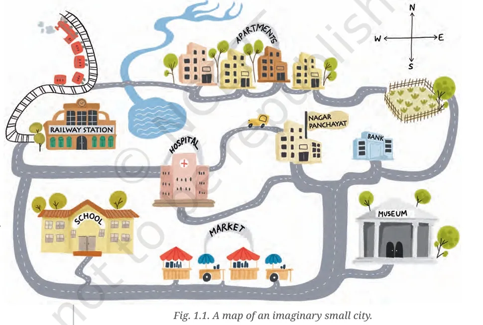
1. Mark the hospital.
Ans. Refer to the map in Fig. 1.1 (Page 8); the hospital is located on the northwestern side of the city.2. What is the meaning of the blue-coloured areas?
Ans. The blue-coloured areas represent water bodies such as lakes and rivers.3. Which is farther away from the railway station — the school, the Nagar Panchayat or the public garden?
Ans. The public garden is farthest from the railway station.LET’S EXPLORE (Page 10)
1. Draw a simple map of a school’s playground. Let us assume it is a rectangle, 40 m in length and 30 m in width. Draw it precisely with your ruler on a scale of 1 cm = 10 m.
Ans. Draw a rectangle of 4 cm by 3 cm using a ruler, representing 40 m by 30 m.2. Now measure the diagonal of the rectangle. How many centimetres do you get? Using the scale, calculate the real length of the playground’s diagonal, in metres.
Ans. Using the Pythagoras Theorem:
Diagonal = √(4² + 3²) = √(16 + 9) = √25 = 5 cm
Real diagonal = 5 cm × 10 m = 50 metresLET’S EXPLORE (Page 11)
1. Consider the map of the small city again. Identify the correct and incorrect statements in the list below:
-
The market is north of the hospital. — Incorrect
-
The museum is southeast of the bank. — Correct
-
The railway station is northwest of the hospital. — Correct
-
The lake is northwest of the apartment blocks. — Incorrect
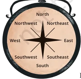
2. Taking your school as the starting point, do you know approximately in which cardinal direction your home is located?
Ans. Students should discuss this with the teacher. For example: "My home is in the northeast direction from the school."LET’S EXPLORE (Page 11 – Symbol Activity)
Draw a rough map of your locality or your village, including your home, school and a few other important landmarks. Show the cardinal directions and use a few of the symbols shown in Fig. 1.2 to mark some important features.
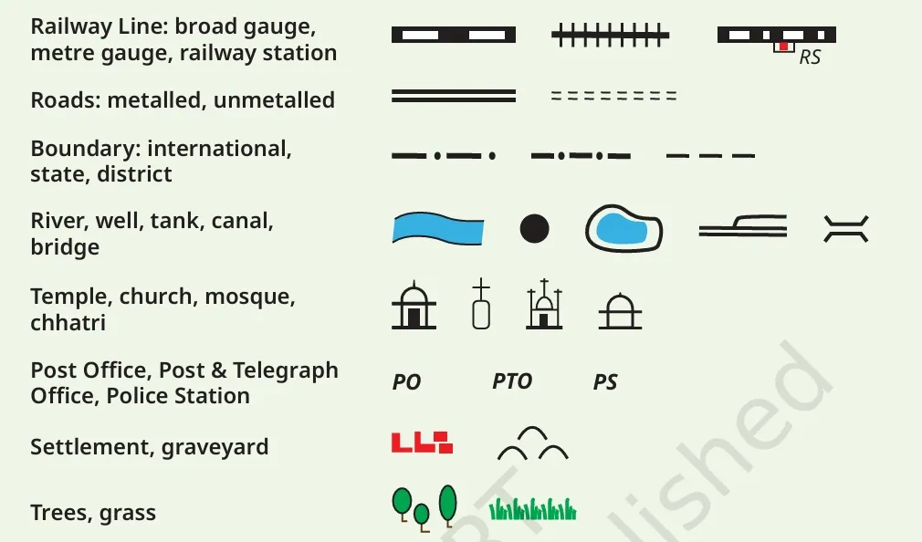
Ans. Students should draw a simple layout with symbols like ⛪ (temple), 📮 (post office), 🏫 (school), 🚓 (police station), 🌳 (trees), and roads/railways using conventional map symbols.LET’S EXPLORE (Page 13)
Using the same terms, write down your move if you play black and respond with the same move.
Ans. White moved d2 to d4.
Black should move d7 to d5.LET’S EXPLORE (Page 17)
If the globe or atlas in your class has well-marked latitudes and longitudes, try to note down approximate values for the latitude and longitude of:
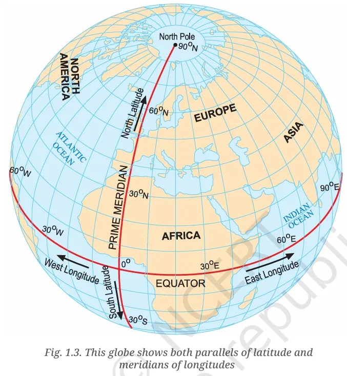
-
(1) Mumbai – 19°N, 72.8°E
-
(2) Kolkata – 22.6°N, 88.4°E
-
(3) Singapore – 1.3°N, 103.8°E
-
(4) Paris – 48.9°N, 2.3°E
LET’S EXPLORE (Page 21)
Two friends, one in Porbandar and one in Tinsukia, are speaking. The sun has set in Assam but not in Gujarat. Explain why.
Ans. India spans a wide longitudinal range. Tinsukia (Assam) lies to the east and experiences sunrise and sunset earlier than Porbandar (Gujarat). The Earth rotates from west to east, so eastern regions experience daylight before western ones.Calculate the difference in local time.
Ans. If the longitudinal difference is 30°, the time difference is 30 ÷ 15 = 2 hours.LET’S EXPLORE (Page 21)
Use the example to explain the difference between local time and standard time.
Ans. Local time is based on the actual position of the sun at a specific longitude. Standard time is the uniform time fixed for a country based on a selected meridian. Though Assam and Gujarat have different local times, both follow Indian Standard Time (IST), based on 82.5°E.QUESTIONS, ACTIVITIES AND PROJECTS (Page 24–25)
1. Calculate the real distance from the estuary of the Narmada River to the estuary of the Ganga river.
Ans. Assuming a measurement of 5 cm on the map and scale of 2.5 cm = 500 km,
Real distance = 5 cm ÷ 2.5 cm × 500 km = 1000 km2. Why is it 5:30 pm in India when it is 12 pm or noon in London?
Ans. India lies 82.5° east of Greenwich. Every 15° of longitude equals 1 hour of time difference.
82.5 ÷ 15 = 5.5 hours. So, IST is 5 hours 30 minutes ahead of GMT.3. Why do we need symbols and colours in the map?
Ans. Symbols and colours help to represent features like roads, rivers, cities, and forests clearly and concisely, especially when space is limited.4. Find out what you have in the eight directions from your home or school.
Ans. Students should survey and list:-
North: Temple
-
South: Playground
-
East: Library
-
West: Market
-
NE: Hospital
-
SE: Bus stand
-
SW: Post office
-
NW: School building
5. What is the difference between local time and standard time?
Ans. Local time is based on the position of the sun at a specific place; it changes with longitude. Standard time is fixed across a country to avoid confusion.For example, although sunrise in Assam is earlier than in Gujarat, both use IST (Indian Standard Time), which is 5 hours 30 minutes ahead of GMT. This simplifies scheduling and communication.
6. Delhi’s and Bengaluru’s latitudes are 29°N and 13°N; their longitudes are almost the same. How much will be the difference in local time between the two cities?
Ans. Since their longitudes are the same, there is no difference in local time between Delhi and Bengaluru.7. Mark the following statements as true or false; explain your answers.
-
All parallels of latitude have the same length. — False
Only the Equator is the longest; others get shorter as we move toward the poles. -
The length of a meridian of longitude is half of that of the Equator. — True
Meridians are half-circles, whereas the Equator is a full circle. -
The South Pole has a latitude of 90°S. — True
-
In Assam, the local time and the IST are identical. — False
Assam is ahead in local time compared to IST. -
Lines separating the time zones are identical with meridians of longitude. — False
They are adjusted to match country borders. -
The Equator is also a parallel of latitude. — True
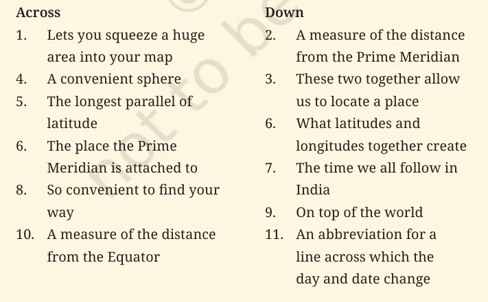
8. Solve the crossword
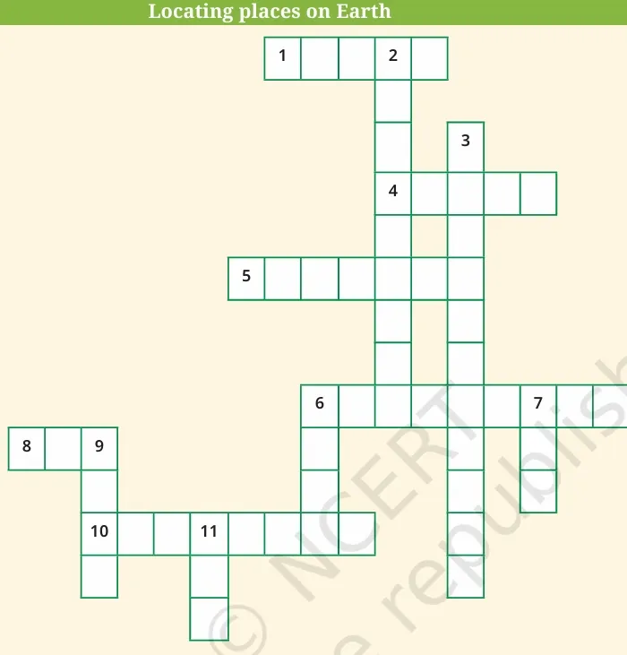
Across
-
Scale
-
Globe
-
Equator
-
Greenwich
-
Map
-
Latitude
Down
2. Longitude
3. Coordinates
6. Grid
7. IST
9. Pole
11. IDL -
Read More: Globe and Map
Key Concepts in Locating Places on the Earth
To use the class 6 social science chapter 1 question answer well, you need to know what the tools and words used in global navigation mean.
The Globe: A True Miniature Model
A globe is a small, three-dimensional replica of the Earth that shows how it really looks. A globe shows the right size and shape of continents, countries, and oceans, which flat maps don't do. The globe has a needle that goes through it at an angle, which is called its axis. The needle goes through two points on the globe: the North Pole and the South Pole. It's vital to remember that the globe may be turned like the real Earth, but the real Earth doesn't have a physical needle; it revolves around an imaginary axis.
The Equator and the two halves of the world
The Equator is an imagined circle that cuts the Earth in half. The Northern Hemisphere is the part of the world that is north of the equator, and the Southern Hemisphere is the part of the world that is south of the equator. The Equator is the line that divides the world into two hemispheres and is an important point of reference for finding places.
Parallels of Latitude
Parallels of latitude are all the circles that run parallel to the equator and the poles. Degrees are used to measure latitudes. The parallels of latitude get smaller as we move away from the equator.
Key latitudes include:
-
Tropic of Cancer: 23½° N in the Northern Hemisphere.
-
Tropic of Capricorn: 23½° S in the Southern Hemisphere.
-
Arctic Circle: 66½° N of the equator.
-
Antarctic Circle: 66½° S of the equator.
Heat Zones of the Earth
The Earth has three main heat zones that are based on how much sunlight they get:
-
Torrid Zone: This zone is between the Tropic of Cancer and the Tropic of Capricorn. This area gets the most heat because the sun is directly overhead at noon at least once a year at all latitudes.
-
The temperate zone: It is between the Tropic of Cancer and the Arctic Circle in the Northern Hemisphere and the Tropic of Capricorn and the Antarctic Circle in the Southern Hemisphere. The temperatures in these places are mild because the sun's rays hit them at a lower angle as they move towards the poles.
-
Frigid Zone: These are places that lie between the Arctic Circle and the North Pole and the Antarctic Circle and the South Pole. Because the sun doesn't rise too high above the horizon and its rays always slant, it's really cold here.
Meridians of Longitude and Time
While latitudes tell us how far north or south a place is, we need meridians of longitude to determine how far east or west a place is from a given line of reference.
The Prime Meridian
The Prime Meridian is the line of reference that goes through Greenwich, where the British Royal Observatory is. The value is 0° longitude. We measure 180° to the east and 180° to the west from it. The Earth is split into two equal parts by the Prime Meridian and the 180° meridian. These parts are called the Eastern Hemisphere and the Western Hemisphere.
Longitude and Time Calculation
The movement of the Earth, moon, and planets is the greatest way to tell time. The Earth spins all the way around in around 24 hours. This implies it spins 15° in one hour or 1° every four minutes.
-
At 15° east of Greenwich, the time will be 60 minutes (1 hour) ahead of Greenwich time when it is midday there.
-
On the other hand, it will be one hour behind at 15° west of Greenwich.
Why do we have Standard Time?
The local time of places that are on different meridians will always be different. For instance, Dwarka in Gujarat and Dibrugarh in Assam have local times that are about 1 hour and 45 minutes apart. To minimise confusion, the standard time must be the local time of a central meridian of a country. The Standard Meridian in India is at 82½° E longitude. The Indian Standard Time (IST) is the time that is used all around the country. This is the time at this meridian.
Also Read: Facts About the Earth Everyone Should Know
How CuriousJr Online Tuition Classes Enhance Learning
CuriousJr’s online tuition classes are specially created for students from Class 3 to Class 8 to strengthen their understanding of subjects and improve confidence in academics. The program includes daily interactive classes that make lessons interesting and easier to understand. Core subjects such as Maths, Science, English, and Social Studies are taught according to the latest syllabus. Regular tests and assessments help monitor student progress, while dedicated mentor support provides personal guidance and helps students clear doubts and bridge learning gaps effectively.


Class 6 Social Science Chapter 1 FAQs
What is Class 6 Social Science Chapter 1 about?
Why are latitudes and longitudes important?
What does "Grid" mean in geography?
How can Physics Wallah Curious Junior help you learn about geography?
Is there a difference between the 180 Degree East and 180 Degree West lines?


Get Free Counselling Today
and Clear up all your Doubts